|
In purchasing equipment for the outdoors, I always use the same thought process. How often am I going to upgrade my equipment based on the new radical improvements that
 the manufacturer will come out with? How long before my existing equipment will become obsolete and I will have to replace it? How long will it be before I have a disadvantage with my existing equipment? When the time came to choose a GPS system, I decided that I would choose the best GPS that I could afford based on the use of the GPS (and in this case, the least expensive model).
GPS is short for for Global Positioning System. By use of the network of 24 satellites that constantly circle the earth, a GPS receiver calculates your location (latitude, longitude, and altitude) using information from three or more of the GPS satellites. This allows you to know where you are (and to navigate to a destination) anywhere on earth. A GPS receiver can take your outdoor adventures further than ever, but make sure to also bring a map of the area with you. Never trust a GPS to help your navigate your entire outdoor adventure since all electrical equipment malfunctions.
The GPS allows you to mark any special place that you would like to return to with a waypoint. This allows you, next time, to find your way back to that special place without getting lost. Just remember the GPS usually has trouble receiving satellite transmissions deep in the woods with high trees, underground, underwater and indoors.
WAAS technology
Make sure the GPS has WAAS (Wide Area Augmentation System) technology. WAAS technology allows the GPS to give you accuracy within 3 meters.
Multi-channel design
Single-channel GPS receivers are outdated and the GPS that you should consider should have a parallel multi-channel design. The GPS has a specific circuit dedicated to a single satellite signal. This allows the GPS to lock in your position fast and accurately with easier navigation through tougher terrain. Take the GPS outside (if you are able to) to see how fast the GPS locks into at least 3 satellites.
GPS memory
The more internal memory the GPS has, the more information that can be stored - waypoints, routes, POI (Points Of Interest), maps, etc. Make sure the GPS has at least 32MB or more of memory if you are going to use mapping. If you are going to use the GPS for sea as well as land, more memory will allow the GPS to get to street-level on land for exact directions. Most memory will be fixed (built into the GPS), but some GPS receivers have removable memory cards.
Waterproof or water resistant?
If you are going to use the GPS for kayaking and canoeing and the GPS is water resistant, a special see-through drybag made especially for a GPS has to be used. Water resistant will be acceptable for all other types of outdoor adventure activities such as hiking and backpacking.
Batteries and battery life?
What type of batteries are used with the GPS? Are they normal rechargeable AA batteries or are they special manufacturer batteries? Extra batteries must be carried along at all times just in case. How long do the batteries last? Is there a battery saver mode (sleep mode)? Do you have to turn the GPS on and off each time to save the batteries? How long can the GPS remain on without turning the receiver off before the battery power runs out?
Map or non-mapping?
The least expensive GPS is the Non-Mapping receiver that just includes a plotter screen that displays overhead the waypoints, the POI (Points of Interest - cities, gas stations, lighthouses, buoy markers, parks, etc.) and routes. No maps are displayed in this receiver. This receiver is actually quite effective for sea kayaking or hiking. The price of this receiver makes this receiver very attractive. A Base Map GPS (the next expensive GPS) displays all the information as the non-mapping unit, but also displays major roads, coastlines, lakes, rivers, highway exits, etc. Mapping GPS receivers bring the GPS to its highest level - total map control with real land and sea maps, marine navigation, restaurants, street addresses, topography, trails and much more (most expensive). You can actually navigate to an exact street address using a map. Usually all maps are downloaded from a CD (extra $). It is really your choice on which type of GPS fits your needs. Remember GPS technology changes very rapidly and the $500 unit that you purchase last year will be sold for $150 next year (or it may not even be available any more). All receivers will get you from point A, to B, to C and to D. If you also want your GPS to be used as navigation for your car, then you must choose the Mapping GPS. I use my GPS for kayaking and hiking and I decided that the Non-Mapping GPS fits my needs quite effectively. Since I must still bring a waterproof map of the area, I prefer to use the waterproof maps as I can see the whole area much better than a GPS screen.
Other features?
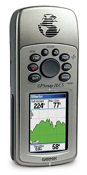
There are many other features, too numerous to mention, that are available on a GPS. Some include compass, altimeter, high and low tides, moon phases, communication (2-way radio built in), etc. Find out about all the extra features and one of them might be important to you.
Don't forget to learn how to maintain your GPS correctly because incorrect methods might damage your GPS and choose a GPS wisely. Always remember to remove the batteries out of the GPS if you are not going to use it for over 6 months (GPS set up might have to be done again when the batteries are replaced).
| 
